News & information from UB, New York's flagship university
Study explores how past Native American settlement modified WNY forests


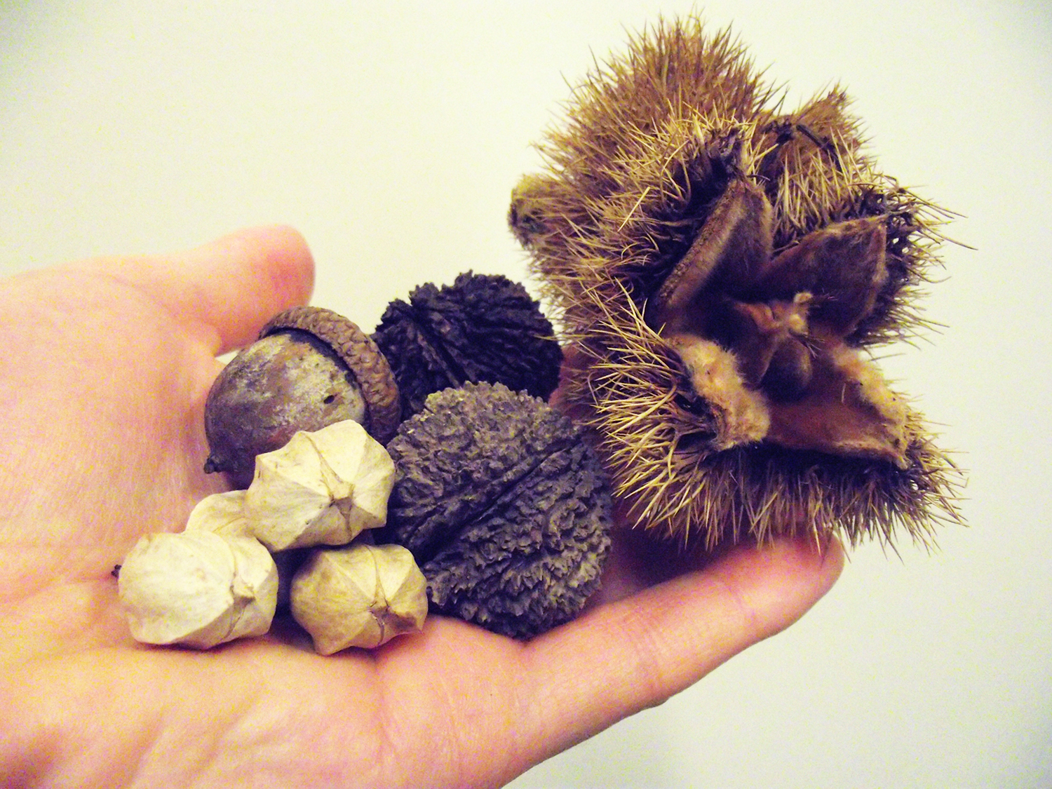
A new study finds that large-nut-bearing trees may have been more abundant than expected near the historical sites of Native American villages in Chautauqua County. Picture from left to right are hickory nuts (the palest); acorns from oak; black walnuts (dark, bumpy shells); and chestnuts (large and prickly). Credit: Steve Tulowiecki
Fire-tolerant trees that bear edible nuts were unusually abundant near the historical sites of Native American villages, research suggests
Release Date: May 28, 2015 This content is archived.


BUFFALO, N.Y. — A new study by University at Buffalo geographers explores how humans altered the arboreal make-up of Western New York forests before European settlers arrived in large numbers.
The research looked at land survey data from around 1799-1814, and used this information to model which tree species were present in different areas of Chautauqua County, New York, at that time.
The analysis placed hickory, chestnut and oak trees in larger-than-expected numbers near the historical sites of Native American villages, said co-author Steve Tulowiecki, who conducted the research as a geography PhD candidate at the University at Buffalo and is now an adjunct lecturer of geography at SUNY Geneseo. This finding is important because these species produce edible nuts, and are also more likely than many other trees to survive fires.
“Our results contribute to the conversation about how natural or humanized the landscape of America was when Europeans first arrived,” Tulowiecki said. “Our society has competing views about this: On one hand, there is the argument that it was a wilderness relatively untouched by man. Recently, we’ve had this perspective challenged, with some saying that the landscape was dramatically altered, particularly through burning and other clearance practices.”
The findings of the new research — more fire-tolerant, large-nut-bearing trees than expected within about 15 kilometers of village sites — suggest that Native American communities in the study area modified the forest in ways that favored those species, Tulowiecki said. He noted that flame-sensitive beech and sugar maples, which burn readily in forest fires, appeared in smaller numbers than expected near village sites.
Forest modifications may have impacted upwards of 20 percent of total land area in modern-day Chautauqua County, according to Tulowiecki’s analysis.
The research is important, he said, because it uses data to address questions surrounding historical forest modification.
“There have been contentious debates over the past few decades regarding the spatial extent of Native American impacts upon pre-European landscapes,” he said. “Yet, very few studies have offered exhaustive methods to understand or quantify these impacts. Our study utilizes advanced quantitative models, geographic information systems, original land survey data, and historical-archaeological records of Native American settlement in order to understand these impacts.”
Tulowiecki, who finished his PhD in 2015, conducted the study with his advisor, UB Associate Professor of Geography Chris Larsen, PhD. The research was published online on May 19 in Ecological Monographs, a journal of the Ecological Society of America.
Picturing a 19th-century forest
To predict how the forest looked 200 years ago, Tulowiecki and Larsen synthesized several sources of information.
They began with the observations of surveyors from the Holland Land Company, who documented the terrain of Chautauqua County between 1799 and 1814. These assessors included details on which types of trees they found at thousands of locations in the region.
Tulowiecki and Larsen mapped this information, then overlaid it with data showing the temperature, precipitation, soil conditions and other environmental variables at different locations. This helped the researchers understand what types of trees typically grew under various conditions, and they used this information to build predictive models showing how all of Chautauqua County would have looked, tree-wise, at the turn of the 19th century if environmental conditions were the only factor at play.
Apparently, they were not, because in some places the distribution of tree species predicted by the model didn’t match the reality of what surveyors saw.
The sites where these discrepancies occurred coincided with the historical location of Native American villages as mapped or described by various sources, Tulowiecki says. This suggested that Native American societies – particularly the Seneca – modified the areas surrounding their communities.
To account for this possibility, the researchers refined their predictive models. In addition to the original environmental variables, they incorporated a new variable that captured information related to proximity to village sites.
The models improved as a result.
Media Contact Information
Charlotte Hsu is a former staff writer in University Communications. To contact UB's media relations staff, email ub-news@buffalo.edu or visit our list of current university media contacts.

