Improving the Sustainability and Productivity of Poor Smallholder Farmers in Northern Ghana Using Electromagnetic Induction Guided Precision Irrigation
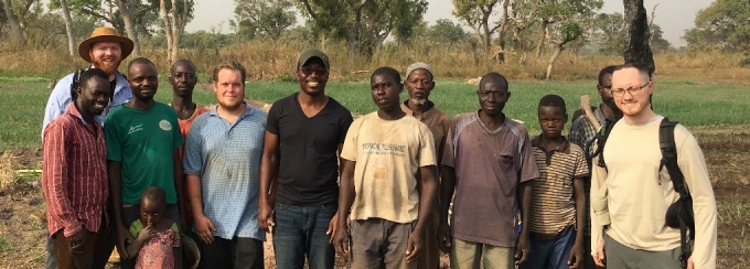

Geophysics research team with farmers from Kparigu, Northern Region after electromagnetic surveying and soil monitoring
Northern Ghana, a semi-arid region with rainfall occurring only 4 to 5 months in a year, has a long dry-season that renders farmers unemployed for 7-8 months in a year. This contributes to widespread poverty in the region - approximately 80% of people in N. Ghana live below the poverty line. The unemployment situation in rural communities motivates farmers to migrate seasonally to urban centers in the south to seek meager jobs to supplement their income. The return on investment is often insubstantial.
Small-scale irrigation from the White Volta River and its tributaries provide employment opportunities for farmers during the dry season. The current small-scale irrigation methods, however, disregard important soil characteristics that contribute to irrigation water retention, leading to inefficient water management practice.
The Geoscientists Without Borders Ghana Project aims to develop a precision irrigation framework for the project region to guide the irrigation scheduling of smallholder irrigation farmers in Northern Ghana for efficient utilization of their limited irrigation water for sustainable food production and food security. Alexander Percy, an undergraduate student of Geology, performed field surveys, including electromagnetic induction soil characterization, field irrigation experiments, and soil sampling to understand the spatial variabilities in soil properties and their ability to hold water for plant uptake. These datasets will instruct the creation of water management zones within a field, and a reference guide to explain how and why farmers should adopt sustainable irrigation methods. Precise application of irrigation water will improve the socio-economic well-being of poor small-scale farmers in the project region by reducing water wastage, reducing farmer stress and fatigue, lowering input costs while increasing output/productivity and profit.
Written by Jessica Scates
- Students:
Alexander Percy (Geology) - Faculty Mentor:
Erasmus Oware (Geology) - Country of Travel:
Ghana - Dates of Travel:
January 2018
Articles and Reflections


Presentations and Publications

Jeremy M. Fontaine, Alexander Percy, Erasmus K. Oware, Patience Bosompemaa, Vincent Gbedzi, and John W. Lane, Jr. (2018) Application of electromagnetic induction to develop a precision irrigation framework to facilitate smallholder dry season farming in the Nasia-Kparigu area of northern Ghana. SEG Technical Program Expanded Abstracts 2018: pp. 2491-2495.
Abstract: Arid climatic conditions coupled with the prolonged dry season in northern Ghana (NG) place great restrictions on year-round smallholder farming. Because small-scale farming is the main source of livelihood for over 70% of rural inhabitants, limitations on dry season farming have contributed to severe poverty in NG. Although the adoption of individual smallholder irrigation in the area is enabling dry season farming, these practices do not account for spatial variability in physical soil properties (e.g., soil texture) that determine the amount of water available to plants. Hence, current irrigation practices in NG are inefficient. Here, we present preliminary results of the development of a precision irrigation framework (PIF) for the Nasia-Kparigu area in NG intended to enable smallholder farmers to make judicious use of limited irrigation water, and facilitate more sustainable dry season farming in the area. We also demonstrate the use of electromagnetic induction surveys to characterize field-scale spatial variability in soil water retention capacity.