News and views for the UB community
the view
Houston’s flooding underscores disaster management challenges
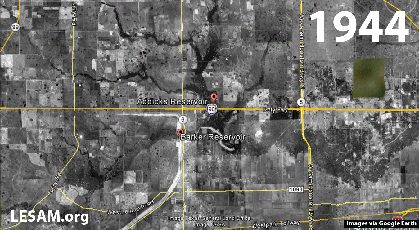
This Google Earth image series produced by Chris Renschler’s team shows land use and land cover transitions around Houston's Addicks and Barker reservoirs since 1944. The images show the location of the reservoir gates and how new developments have crept closer from the East toward and around the reservoirs as time has passed. As a consequence, thousands of homes that are now too close to the maximum reservoir level have reportedly been flooded and will likely deteriorate while sitting in floodwater for longer, as happened after Hurricane Katrina in New Orleans, Renschler says. Image: LESAM.org/University at Buffalo/Images via Google Earth.
By CHARLOTTE HSU
Published August 31, 2017 This content is archived.


As the Earth’s climate changes, many scientists predict that warmer temperatures could lead to intensifying hurricanes, with individual storms dropping more rain.
As such, the massive flooding caused by Hurricane Harvey in and around Houston may presage the challenges that disaster managers will face in the years ahead, says UB disaster researcher Chris Renschler.
Renschler, associate professor of geography in the College of Arts and Sciences, researches extreme events, including soil erosion and flooding.
“In Houston, the situation is absolutely devastating,” he says. “This is an unprecedented precipitation event, but it should give us the motivation to think about these unprecedented events, particularly in hurricane-prone areas.
“These kinds of floods are not wholly natural,” he says. “They are the result of both natural and human-driven processes. Humans can’t fully control nature, but we can control decisions such as where to build new residential developments, where and how to build temporary storages for flood water, and when to open the floodgates of a dam. We can also control how we communicate with the public about the risks of flooding.”
These quandaries are not unique to Houston — communities across the U.S. face similar challenges and should continuously revisit and adapt their emergency plans and communication procedures, says Renschler, who is teaching a class this semester that focuses in part on building community resilience against floods and other extreme events.
He says that to protect communities, emergency managers, public officials and other decision-makers must work together, training for worst-case scenarios and planning ahead so that people who may be affected by flooding understand the risks long before a crisis has begun.
Renschler notes that decisions made years in advance can have a huge impact on the severity of a disaster. Land use planning, for example, influences not only how water moves through a landscape, but also who will be in the path of a flood.
“In the Houston metro area, which had some of the country’s fastest population growth over the past decade, development of residential and commercial areas in the watersheds of important flood-protection reservoirs increased impervious surfaces. This exacerbated runoff by reducing the infiltration of water into the soil,” Renschler says.
“It also transformed a rural landscape into suburbs, worsening the emergency by putting more people and structures in potential harm’s way and limiting the options once such storms hit,” he says.
In the case of the Addicks and Barker reservoirs, which were built in the 1940s in a mostly undeveloped landscape to capture water upstream of the Buffalo Bayou, development left the Army Corps of Engineers and local emergency managers with limited options.
When the reservoirs began to fill, officials had to decide how to release water from dams in a way that balanced the needs of two groups of residents — those living in developments built upstream near the reservoirs, and those living downstream. Open the floodgates and water moves downstream, but keep them closed and more of the water stays upstream, flooding adjacent subdivisions that sit against the dams.
“Where flash flood management is an issue, different agencies and stakeholders must better work together on short-term management of crisis situations, as well as long-term sustainable growth and careful development,” Renschler says.
Lessons from Tropical Storm Irene
Renschler is a member of the Local Emergency Planning Committee in Erie County, New York; was part of Gov. Andrew Cuomo’s Respond Commission after Superstorm Sandy; and is working for the United Nation’s International Atomic Energy Agency with more than a dozen country representatives as an invited expert on flood-risk mitigation and post-flood rehabilitation efforts in Asia.
At UB, Renschler directs the Landscape-based Environmental System Analysis and Modeling (LESAM) lab.
Together with Jared Flagler — a UB geography master’s graduate who specializes in watershed modeling and landscape analysis and management with GIS, Renschler is monitoring the situation in Houston. They are keeping track of reservoir water levels, stream gauge data, and the dissemination of emergency information to the public by water resource and disaster management officials.
Though Renschler is not involved officially in the Hurricane Harvey response, his past work includes disaster assessment.
In 2011, for example, after Tropical Storm Irene, he led UB researchers on a mission to document flood damage in the Schoharie Creek watershed, west of the Catskill Mountains. The team combined these field site observations with hydrological data, aerial imagery and elevation data to determine the extent of the flooding and destruction, verifying that the disaster was a 500-year event and describing the challenges of communicating flood dynamics around dams.
The research, published this year in the International Journal of Applied Earth Observation and Geoinformation, could help emergency planners utilize existing and newly collected data, and develop more accurate watershed models and flood maps to better protect and prepare Schoharie Creek communities in responding to future extreme events.
When it comes to water management, the challenge is “to anticipate changes and prepare and invest in realistic planning scenarios in time to not get in these situations with rather limited management options,” Renschler says.