
News
Using crowdsourcing to track stream levels
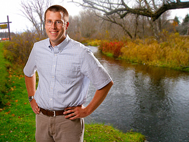
Geologist Chris Lowry is using crowdsourcing to monitor the water levels on local streams. Photo: DOUGLAS LEVERE
-
 Print
Print -
 Comments
-
“When I heard that this guy was actually getting people to send him info on roadkill, I thought there’s no reason I couldn’t get people to send me info on how much water is flowing through streams.”
Inspired by a California researcher who used crowdsourcing to pinpoint the locations of roadkill, a UB geologist is turning to the public for help monitoring a different ecological phenomenon: the water levels of streams in Western New York.
Like other examples of crowdsourcing, the UB effort, called “CrowdHydrology,” harnesses the collective efforts of many different people to complete a task. With tight budgets forcing the U.S. Geological Survey to discontinue the recording of water levels at many streams the agency has monitored for decades, CrowdHydrology could serve as a model for communities looking for a cost-effective method for maintaining some data on local waterways.
The project launched this May with a pilot site at the Beaver Meadow Audubon Center, a Buffalo Audubon Society nature preserve in Wyoming County.
At the preserve’s main pond, UB faculty member Chris Lowry hammered a giant measuring staff into the pond bottom, along with instructions explaining how passersby could contribute to CrowdHydrology by texting the water level and stream location (identified by a station number) to researchers.
With visitors now sending in data from Beaver Meadow at least a few times a week, Lowry, an assistant professor in the Department of Geology, is expanding CrowdHydrology to nine new sites in Western New York. Possible locations include four sites on Cattaraugus Creek; three on Wiscoy Creek; and one apiece on Elton Creek, Clear Creek and Hosmer Brook.
Installation will take place this month, with each new stream gauge costing about $60. The precise position of the new stations, along with updates on reported water levels, will be posted on the CrowdHydrology website.
Besides benefiting such sportsmen as local fishermen, monitoring streams will provide useful data to scientists—including Lowry’s graduate students—whose research requires taking samples or conducting experiments on local creeks when the water is at a certain height.
“I’ve been pleasantly surprised by the results so far,” Lowry says. “At Beaver Meadow, I’ve gotten 25 different people texting me, and I get readings just about every day. The consistency of the data is also good.
“I got the idea for CrowdHydrology from an article I read about using smartphones for science,” he adds. “There’s a faculty member from UC Davis who was tracking wildlife corridors by asking people to send him information about roadkill on roadways. When I heard that this guy was actually getting people to send him info on roadkill, I thought there’s no reason I couldn’t get people to send me info on how much water is flowing through streams.”
As a tool for science, crowdsourcing has obvious limitations, and Lowry is quick to point these out. Though he plans to verify data from one CrowdHydrology station by installing a device called a pressure transducer to double check water levels, he acknowledges that he won’t be able to say for certain whether every piece of data from every site is accurate.
Another problem: The frequency of incoming reports has varied, with Lowry noticing a dropoff in texts during a recent heat wave. The stream gauges that the U.S. Geological Survey maintains, in contrast, typically record exact measurements at hourly or 15-minute intervals.
So far, though, CrowdHydrology is doing well. About 50 texted reports have arrived from Beaver Meadow in just two months, and of those, only three data points appear to be off-target, Lowry says.
As for what comes next, Lowry hopes to improve CrowdHydrology by automating data retrieval and posting. For the moment, when Lowry receives a water-level report, he manually updates a Google spreadsheet that then feeds the information to the CrowdHydrology site. Automating the process would save time, especially as new reporting stations come online.
To further expand the project, Lowry would like to secure a small grant that will enable him to provide stream-gauge packages to K-12 teachers. Participating in CrowdHydrology could be a fun way for students to learn about local streams and how waterways respond to rain and dry spells, Lowry says.
Already at Beaver Meadow, the project is serving an educational purpose, says Loren Smith, executive director of the Buffalo Audubon Society.
“We use it as a teaching tool,” Smith says. “We take folks down to the stream gauge to help them learn about how water flows through our ecosystems. This project is a wonderful way to engage students and citizens in basic research that helps illuminate and explain our natural world. It forms the underpinning for understanding the natural habitats and ecosystems that we have been charged with stewarding.”
Reader Comments