
Archives
Dig less, learn more with technology
Geophysics, GPS are playing important roles in excavation of ancient Roman fort
By ELLEN GOLDBAUM
Contributing Editor
For centuries, trowels and handpicks have been traditional tools of the trade for archaeologists, but a UB geophysicist who has been working at an archaeological site in Jordan is proposing that some decidedly 21st-century technologies, like tablet PCs equipped with fancy navigational software, ought to be standard gear as well.
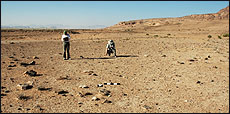
In the middle of the Jordanian desert, UB researchers used geophysics and GPS to help archaeologists locate important subsurface features of an ancient Roman fort.
"Non-invasive geophysical techniques, which allow researchers to image what's under the ground without digging, and real-time differential Global Positioning Satellite (GPS) technology, which provides resolution and accuracy to within a meter, can provide archaeological teams with significant benefits," said Gregory S. Baker, associate professor of geology in the College of Arts and Sciences.
By helping archaeological teams target with greater accuracy where an excavation will provide the greatest archaeological "payoff," the integration of both of these techniques on a commonly available—and portable—platform like the tablet PC could save them time and money, he added.
This past summer, Baker successfully used these techniques at the excavation, led by John Oleson of the University of Victoria, of an ancient Roman fort in southern Jordan.
Baker said it's an example of how geophysical techniques used to image subsurface features non-invasively can prove critical in helping archaeologists determine where to start excavating to find suspected features.
He has submitted a proposal on this methodology, which he calls "synergistic archaeogeophysics," to the National Science Foundation (NSF).
Typically, Baker explained, after the geophysical data are collected and processed, archaeologists view them on a computer screen, then try to locate the suspected subsurface features in the field.
"The trouble lies in translating the geophysical images we collect into something that is truly useful to archaeologists," said Baker.
"Right now, it's pretty archaic," he said. "An archaeologist will try to locate a feature in the field using a tape measure and a printout of the geophysical data."
This past summer, Baker applied real-time differential GPS to the Jordanian project.
Archaeologists at the Jordanian site are looking for evidence that the Roman fort may have included a large kiln site, indicating that as the Romans moved into a new area and conquered territory, they established a local means for producing pottery.
"There's tremendous interest in whether or not there was a large-scale kiln area at this site," said Baker, noting that the fort is one of the few examples in Jordan of an ancient Roman military installation.
"We were looking for a magnetic signal under the surface because once you heat earth past the Curie temperature, as would be the case during the firing process, it acquires a permanent magnetic signal that persists even today," he said.
Using magnetometers, Baker, along with Heather Ambrose, a master's-degree candidate in the Department of Geology, and Scott Gagliardi, an undergraduate geology major, surveyed the area in an effort to identify subsurface areas with magnetic signatures.
They found some localized "hot spots," which Baker said "have a pretty high likelihood of indicating there's a kiln there.
"Since we collected the magnetics data with real-time differential GPS, we were able then to come back to the archaeologists, show them the images and give them the exact latitude and longitude coordinates," said Baker.
"When they returned to the field, they were able to locate these coordinates to within one meter, even though this was the middle of the desert and there were no landmarks to assist them," he said.
If the archaeologists had not used the real-time differential GPS, Baker said the best they could have hoped for would have been to pinpoint coordinates to within 20-30 meters, which would have made finding the "hot spots" practically impossible.
The archaeologists now are excavating up to three meters below the earth's surface, which is where Baker's data indicates they should find the kiln.
Baker's research at the site is funded by the NSF.