By ELLEN GOLDBAUM
Contributing Editor
A new risk map that reveals the hazards most likely to occur in the
future on Popocatepetl—located just 60 kilometers from Mexico City and
considered the planet's riskiest volcano—has been developed by UB volcanologist
Michael F. Sheridan and colleagues at UB and the National University
of Mexico (UNAM).
| |
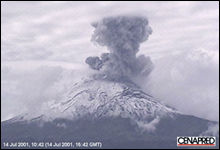 |
| |
Popocatepetl,
located 60 kilometers from Mexico City, is considered the planets
riskiest volcano. |
The map shows which areas will be in danger if a catastrophic event
occurs at Popocatepetl and allows civil authorities in Mexico to make
more informed evacuation decisions since it more precisely forecasts
which areas an eruption's mud flows and avalanches are likely to reach.
The researchers decided to develop the map following the volcano's
eruption last December, its most violent in historic times. Since then,
Popocatepetl has continued to experience "sporadic, large eruptions,"
Sheridan said, and Mexican authorities are watching it closely.
According to Sheridan, Mexican researchers have state-of-the-art systems
in place at Popocatepetl to monitor significant changes in what has
been called the world's most monitored volcano.
"What's been missing is an equally advanced method of predicting just
which populations actually will be in danger," he said.
A more accurate map became a critical priority, Sheridan said, following
Popocatepetl's increased activity last winter.
"We've constructed these sorts of models after the event," said Sheridan.
"But when you do that, people comment that, of course, you can correctly
adjust the parameters after the event. But could you do it beforehand?
So, from a humanitarian point of view, we decided we really wanted to
make this forecast. We want to save as many people as possible."
After Popocatepetl erupted last December, Sheridan, along with UB
geology professor Marcus Bursik; Bernard Hubbard, former doctoral candidate
in the UB Department of Geology, and colleagues at UNAM, began using
newly acquired digital topography to model the hazards the recent activity
represents.
Digital topography represents topographic information by providing
a grid of data points that specify elevation values for each individual
grid area in the region being studied. Sheridan explained that the earlier
hazard map of Popocatepetl was based on a grid spacing of hundreds of
meters, a scale that omitted many important geologic features.
Data points now available and obtained from satellite data provided
by NASA are separated by only 90 meters, a huge improvement, Sheridan
said. He and Bursik now are working on new data points for Popocatepetl
and other volcanoes separated by only tens of meters.
The improved resolution, however, results in a much larger dataset,
making calculation of the flow paths and visualization of the data more
time-consuming and far more demanding computationally.
To churn through all that data, the UB researchers use supercomputers
at the university's Center for Computational Research.
"This new map is a major refinement," Sheridan said, in comparison
to the 1995 hazard map of Popocatepetl that he and UNAM researchers
developed. "We have been able to use actual volumes of flowing material
to demonstrate different levels of damage, based on how violent the
eruption is."
During the past six years, Popocatepetl has exhibited intermittent
phases of activity, explosively ejecting gases and particles, and then
emitting only an occasional steam burst.
But December's active period was different, Sheridan said.
"Having red hot rocks thrown miles from the top of the volcano—that
hasn't happened in historic times," he said.
"It now has been more than 1,200 years since an eruption that seriously
affected human habitation and that's what makes it a little scary,"
said Sheridan. "The volcano could go into a more dangerous phase at
any time."
From field studies that include radiocarbon dating of samples taken
from the mountain, scientists now know that catastrophic eruptions happen
at Popocatepetl about every 1,000 years. The last large eruption that
affected a population center is the one that occurred about 1,200 years
ago Sheridan said, and products of that wiped out most of the area now
occupied by Puebla, a city that is only 40 kilometers away, and is home
to about 1 million people.
