Students take on volcano during break
Geology class spends spring vacation working on Colima's lava flows, rather than tans
By DONNA
LONGENECKER
Reporter Assistant Editor
Marcus
Bursik describes Colima, the most active volcano in North America, as
"a creature of habit." Located in western Mexico, Colima's habits of
late include rock avalanches, frequent explosions, lava flows, sporadic
ash emissions and earthquakes. And there's also the possibility of a
full-scale eruption in the next five to 10 years if it continues its
100-year cycle.
| |
 |
| |
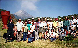
UB
geology students and their Mexican counterparts spent spring break
studying Colima's eruptive patterns and talking with residents about
what it's like to live beneath an active volcano. |
| |
|
Bursik,
a professor of geology, took students enrolled in his advanced field
methods class—who passed up spring break's bacchanal on hot Mexican
beaches—to study Colima's eruptive patterns close-up and talk to
area inhabitants about their evacuation experiences and what it's like
to live beneath "el Volcán de Fuego," or "volcano of fire," as
Colima is known.
Bursik
and his students only were able to get within three to four kilometers
of the crater, but even at that distance, everything was highly visible
since the volcano itself is so big.
"Several
nights we went out and watched these glowing avalanches—it's like
these big, gigantic, house-sized boulders breaking and bursting apart
on the slope and you see all these sparks flying out—just hundreds
of them at a time. It's really beautiful, and during the day, they look
like clouds tumbling down the side of the volcano," says Bursik.
The
goal of the trip was to familiarize students with an explosive volcano
and volcanic terrain by mapping lava flows and rock formations, studying
sedimentation and stratification of flows and debris, and trying to
understand how area inhabitants react and interact with the volcano.
The
students also took part in a cultural and scientific exchange with students
from the Universidad Nacional Autónoma di México.
While
Colima's last major eruptions were in 1818 and 1913, its record of activity
dates back to 1580. Since 1991, the volcano has been erupting constantly
on a smaller scale, but not without peril to the area's residents. "The
experts down there think that this is a build-up cycle before its big
eruption," Bursik explains. "This one does tend to cook along for awhile
and it's in a phase where it's building up to some peak event at some
point." But that may or may not happen, notes Bursik; the volcano also
could just die out.
Part
of the students' work required mapping areas of the volcano, especially
volcanic flows, that could help decide where future development should
or shouldn't occur based on risk assessments of the areas of highest
volcanic activity.
Tracking
Colima's seismic activity on a daily basis is important to the farmers
and villagers who live in the volcano's shadow, but much also can be
learned by creating a historical picture—studying and dating rocks
to find out what the volcano's eruptive pattern has been over hundreds
and thousands of years, says Bursik.
"It's
a real problem when you go to these places and see the misery that the
volcano causes and how big an effect it has on people right there,"
he adds. Because most of the inhabitant's wealth is tied up with their
land, an unnecessary evacuation can devastate a village—residents
are forced to leave and when they return, most of their meager belongings
having been looted.
"This
causes incredible problems. There are many more cases where people were
needlessly evacuated and their economic activity stopped because they
came back and had no life left—there are many more cases of that
than of people being evacuated and the volcano destroying everything,"
says Bursik.
By
developing maps that show past lava flows and possible routes for future
flows—overlaid with information about where people live and their
economic activity—volcanic hazards can be better understood by
civil authorities responsible for evacuations, Bursik says.
"The
mapping has a lot to do with the problem of how society treats it (the
volcano) because it's only by learning how these things act that we
can figure out whether or not some place is in danger," he says.
Moreover,
when it comes to reading and interpreting the types of activity on the
volcano, Bursik says, "The residents are quite savvy—the ones who
live really close to the volcano. The ones who live father away are
less savvy because they don't see a lot of the details." The people
in villages closest to the volcano have been trained to recognize its
dangers and are coming to terms living with its constant eruptions and
the variety of loud, explosive noises it makes.
Bursik
expressed the hope that he can get the UB and Mexican students together
again as part of a cultural exchange of scientists and future scientists
working together to study volcanoes here in the U.S.
He
noted that a graduate student who participated in the spring break trip
to Colima plans to return to study an area that was once a company town
and was buried by a debris flow in 1955.
Bursik
said the State of Colima is building a database related to the volcano's
activities, which he hopes to contribute to, further enhancing knowledge
about the risks and hazards of living in the area.
While
Bursik is sensitive to the difficulties of the people who live near
the volcano, he also tries to remain focused on science, which he sees
as offering the best hope of preventing future catastrophes.
"The
effect it has on me," he says of witnessing the hardships suffered by
the area's residents firsthand, "is to want to do as good a job as I
can in my capacity and understand the volcano as well as I can so these
warnings are as tightly constrained as possible so there are no needless
evacuations—and there are evacuations when they're needed."
